
The sun rose astern as we quietly slipped out of Risby Cove in glassy conditions. Motoring on our port engine at 6.3 knots, we passed through a benign Hells Gate at 08:00. Once south of Cape Sorrell we found an eight-knot breeze, set the main and jib, and motor-sailed in relaxing conditions at 5.7 knots.
At 11:09, we spotted our first whale of the trip – a pilot whale. Alas, it dived before we could take photos. Two hours later, as we passed Pont Hibbs, the wind dropped to a paltry four knots. We adjusted our course 10° east for Low Rocky Point, which we reached at 17:50. Another easterly course adjustment followed that would take us just south of Shark Jaw Reef.
Our destination was Port Davey, the cruising grounds at the far end of the Tasmanian Wilderness World Heritage Area; a place that delights hikers and sailors alike that is only accessible by light aircraft or boat. In contrast to Macquarie Harbour, the approach to Port Davey is wide and welcoming, albeit less so in strong westerly conditions. We headed for Whalers Cove, the anchorage that is nearest the entrance and the one that requires the least amount of navigation. Shortly before midnight, we anchored in calm conditions at a depth of 9m and promptly crashed into our beds. Our “day sail” had covered 98 nautical miles in 17 ½ hours.
 |
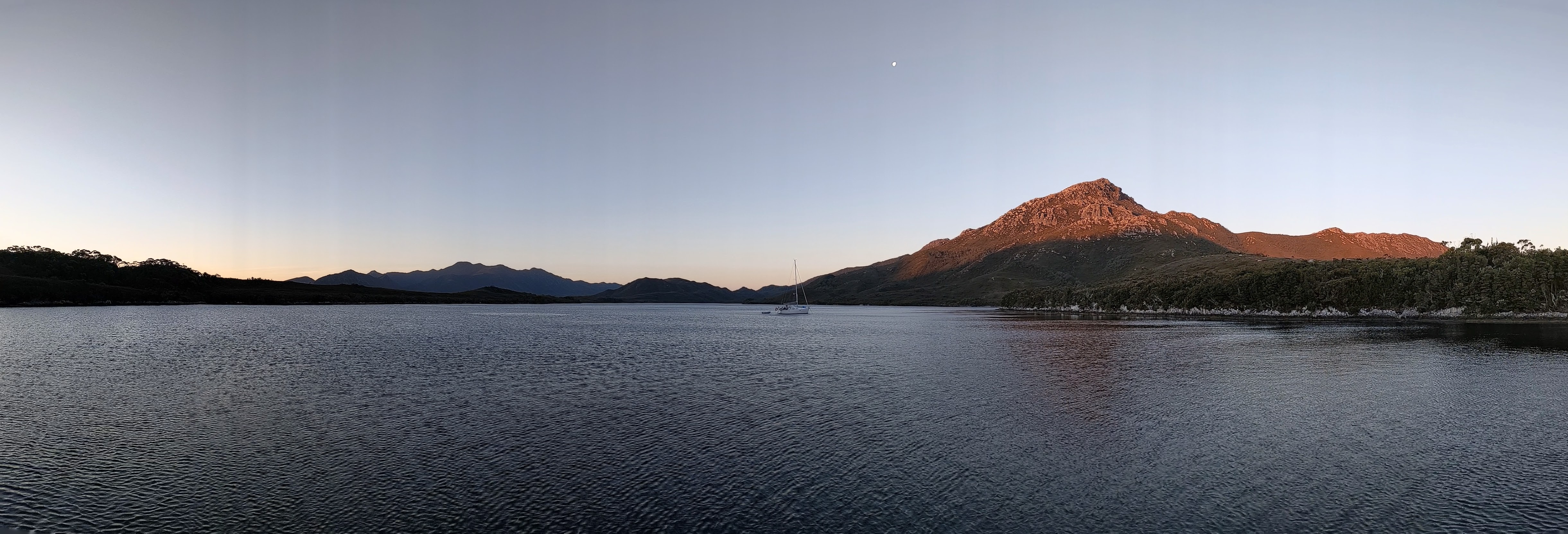
| Seaward entrance to Bathurst Channel. |
The following morning we treated ourselves to a leisurely ten o’clock start. We skirted the north side of the appropriately-named Breaksea Islands that protect the entrance to the Bathurst Channel. The sun came out just as we entered the channel and for the next two hours, we enjoyed stunning vistas and mirror-flat waters. Our first stop was Casilda Cove, seven nautical miles away. Two yachts already occupied the best positions in the small cove so we anchored further in, closer to rocks than ideal. After lunch, we went ashore and hiked to the top of nearby Balmoral Hil. The 1.6km trail is only accessible by boat as it is disconnected from the park network. For a very modest amount of climbing, this hike affords stunning views and is highly recommended.
 |
| Balmoral Hill vista. |
Thirty minutes later we anchored in the cove I’d spotted earlier (not named on charts). I immediately jumped into the water to inspect the damage. Fortunately, our first ding of the trip (and hopefully our last) was just a 30cm-long scrape about 5mm deep along the outer edge of the starboard mini keel. Phew!
Just before sunset, Meredith and I took the dinghy ashore and walked along the beach. The sand was very coarse, yet soft, and as our feet sank in it was like receiving a shiatsu treatment. We enjoyed it so much that we walked up and down the beach twice.
The following day turned on glorious sunny weather. Mt Rugby, the tallest peak in the region at 773m, was beckoning. The peak is often shrouded in clouds and Liam and I had already decided that we would only climb it in good weather. Well, we would be hard-pressed to have a more-perfect day so, at 09:47, we weighed anchor and relocated to Iola Bay, 2 ½ nautical miles away. From there Liam and I took the dinghy across to the trailhead on the northern side of the channel, Meredith and Vela being happy to lounge aboard Arriba in our absence.
As for the Balmoral Hill hike, the Mt Rugby hike is only accessible by boat. Unlike the former, it is a grueling seven-hour round-trip climb, in most places better described as a wombat track than a trail. Nevertheless, the marvelous views from the summit justified our exertions. Click here for my 360° panorama from Mt Rugby.
 |
| Mt Rugby Vista. |
Around 19:00 we had a minor emergency when the anchor briefly drifted. I reset the anchor, paying out more chain, and in the process the dinghy’s painter wrapped around the port prop. It was still light so I dived in and untangled the rope and enjoyed an impromptu evening swim.
The next day we were underway at 06:29, not because I like early starts (although I do) but to take advantage of the rising tide. Our destination was the landing at Melaleuca Inlet, six nautical miles away. The inlet is a windy narrow creek that is flanked by a mix of lush temperate foliage and heath. We found it to be a more intimate, varied, and adventurous nature experience than the lowest reach of the Gordon River. In two places the creek opens up into wide shallow lagoons and it is here that one must be extremely careful to stay on course, as indicated by wooden sticks delineating the channel. The main channel is less than 2m deep at high tide so keelboats need to be particularly careful.
The inlet is not navigable for yachts beyond Melaleuca Lagoon. The same two boats from Casilda Cove two days earlier had again pipped us and tied to the remains of an old wharf, having come on the previous evening’s high tide. Our only option was to drop our anchor in the middle of the creek and tie our stern to one of the many large trees lining the water’s edge, a feat Liam accomplished by taking the dinghy ashore. Satisfied that Arriba would neither drift away nor run aground, we took the dinghy up river another half a mile to the official dock (I’m guessing suitable only for vessels that draw less than 0.5m). From here, it was a short walk to the airstrip and the hut that serves as the waiting room. The big attraction was free WiFi and my crew scrambled for their phones and laptops as if they were rediscovering a long-lost civilization. The next internet access would not be until we reached the town of Southport, many days away. (Arriba does have Iridium Go satellite internet for weather and emergency communications but the bandwidth is inadequate for much else).


Arriba at Melaleuca Inlet.
We were back on board at 13:35. The depth had fallen another 0.5m so we waited two hours for the tide to start rising before departing. Then with the confidence that comes only from having a GPS track to trace, we sped downriver in under an hour. When we re-entered Bathurst Harbour the wind was a steady 20 knots from the ESE, the best sailing conditions in over a week. We sailed to Moulters Inlet where we considered spending the night but we found it to be shallower than the charts indicated – an actual depth of 2.1m at high tide vs 2.5m AHD on the chart – and would have required anchoring hundreds of meters from shore. Instead, we re-entered the Bathurst Channel where, under mainsail alone, we extracted 6.2 knots boat speed from a 10-knot breeze. Our home for the night would be Clytie Cove. This pretty cove has deep water to within 30m of the heavily-wooded shore, making it possible to tuck in close to escape from the wind, tying to a tree if necessary.
 |
| View of Mt Rugby from Clytie Cove. |
 |
| Seaward view from Mt Milner. |
For the past four days, we’d been enjoying the protected anchorages of the Bathurst Channel but for our last night, we returned to Port Davey. At 07:41 we set out for Paine Bay where we anchored southwest of Bar Point. From there we explored the first 5km of the Davey River by dinghy. The highlight was encountering large numbers of black swans who took to the air by the hundreds as we approached. The river is deep enough to go further but there are many submerged and partially-submerged snags. The trip would be inadvisable after a big rain which likely clogs the river with all manner of flotsam.
After lunch, we moved to Spain Bay, 9.4 nautical miles to the south, where we anchored at a depth of 4~5m off the southern beach. The bay, which offers protection from all but the NW quadrant, is the ideal staging point when sailing south from Port Davey. In the meantime, we had time for one last hike, namely an easy jaunt to Stephens Bay – a 3.85km round trip. Standing on that windswept beach, we gazed upon the wild Southern Ocean. In 18 hours we would be on that ocean, bound for South East Cape, one of the five great capes.
 |
| Spain Bay happy hour. |
OVER.
PS The Tasmanian Anchorage Guide recommends two weeks to do Port Davey justice and to explore every nook and cranny it would probably take that. But in five days, blessed with fine weather, you can certainly pack a lot in.
PPS The story continues here.
Great reading. You certainly pack a lot into your trips! Photos were awesome too!
ReplyDelete