In a week or so, I'm setting out on a sailing trip from Adelaide to Perth, a distance of about 1,350 nautical miles, plus or minus detours. The Western Australian Cruising Guide (WACG), which is a free publication of the Fremantle Sailing Club, has been an invaluable trip planning tool. One piece of advice that resonated with me is that nautical charts are not 100% reliable in some out-of-the-way locations, such as the Abrolhos Islands. The WACG suggests the use of Google Earth satellite images with OpenCPN as a way to resolve such charting discrepancies.
This brings me to Chartlayer, a simple web app I wrote for making raster nautical charts using imgkap. The latter, which is a command-line app that runs on Linux, Windows, and macOS, does the hard yards of converting the satellite image into a geo-referenced raster nautical chart, the so called KAP file.
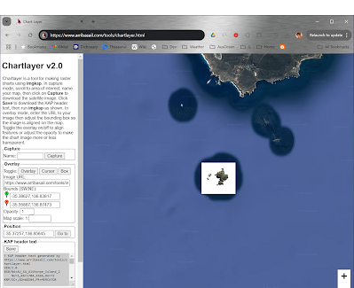
I originally wrote Chartlayer ten years ago to overlay scans of paper charts on Google Maps. Recently, I added a capture mode that grabs Google Maps satellite imagery instead (which is identical to Google Earth imagery). Simply position the Google Maps window over your area of interest and click on the Capture button, to download the chart, e.g., chart.png. For example, I captured Althorpe Island in South Australia (top photo). The screen shot below is a zoomed-out view of the captured area.
Tip: In Chrome, use Full-Screen Mode (F11) to maximize the captured area.
Next click on the Save button to generate and download KAP header text, e.g., chart.txt.
Then it’s just a matter of running imgkap to generate the kap file, as follows.
imgkap chart.png chart.txt chart.kap
Then it’s just a matter of running imgkap to generate the kap file, as follows.
imgkap chart.png chart.txt chart.kap
The KAP file is then imported in OpenCPN.
 |
| Before: Paper chart of Althorpe Island using overlay mode. |
 |
| After: Satellite image of Althorpe Island using capture mode. |
Note that I manually removed the background from the image using a background remover tool in order to show the zoomed-out area. In general it is better not to do this, in which case the satellite image will include all of the adjoining waters and any whitewater.
Satellite imagery should only be used to complement your nautical charts. It is not a replacement.
Let me know what you think.
OVER.


I just came across this page in November of 2025. Unfortunately, Chartlayer seems to be broken, and looking at the JS console it appears to be that Google changed some of the elements or API calls on you. Sorry I can't be more help, my JS skills are severely lacking.
ReplyDeleteThanks for pointing out. It was due to a bad Google Maps API key. Fixed now.
DeleteThanks for fixing that Alan. Quick follow up - in the post, you mention that imgkap is compatible across platforms, but the linked repo only seems to have the windows binaries. Is there another repo out there that might have a *nix compatible build?
DeleteI think you'll have to compile it yourself on *nix platforms. The repo is: https://github.com/nohal/imgkap
Delete