
 |
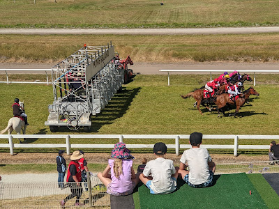
| King Island races. |
The following day we rented a car. I was keen to visit Grassy Harbour on the eastern side of the island since it is described in the Tasmanian Anchorage Guide (TAG) as the preferred anchorage. While the harbor itself is well protected, there is little of interest for the visiting yachtie. The nearest settlement, Grassy, is a steep climb over four kilometers away and offers few amenities, except the Wild Harvest Restaurant. By contrast, Currie is an easy five-minute walk from its harbor and has everything the traveler needs, including a pub, supermarket, bakery, pharmacy, two hardware stores and rental cars. Currie Harbour’s only shortcoming is that it is exposed to strong westerly weather.
We drove to an ancient calcified forest although, technically, just the roots were calcified, not the trees. But the name “calcified roots” does not have quite the same ring to it. The day’s highlight, however, was lunch at the King Island Dairy. The island is famous for its cheeses and we were not disappointed by the sumptuous cheese platter, washed down by a delightful Tassie Pinot Gris. After lunch, we drove north to Australia’s tallest lighthouse at Cape Wickham, which rises to an impressive 48m.
 |
| King Island Dairy cheeses. |
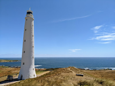 |
| Cape Wickham Lighthouse. |
Around 17:00 we quietly dipped below 40.644°S, the latitude of Woolnorth Point, the northernmost point of the main Tasmanian island. This meant that we were now sailing along Tasmania’s west coast, albeit twenty miles offshore. The day’s pure sailing was short-lived, as the wind faded two hours later and we reluctantly fired up the “iron sail”.
Tasmania’s west coast, which stretches for 180 nautical miles from north to south, is mountainous, sparsely populated, and lashed by wild weather at all times of the year. It is also undeniably beautiful. Numerous peaks form a patchwork of mountain ranges that parallel the coast, the largest of which is the West Coast Range. The trick to sailing comfortably in this part of the world is to avoid the low-pressure systems that move in from the west, bringing high winds and big seas.
Our first taste of Tasmania's mountainous magnificence was the spectacular Mt Cameron West, which rises from the northern end of Ann Bay. It beckoned us to admire its shapely contours as it basked in crepuscular golden rays. We anchored in the southeast corner of the bay at 21:08, 15 hours and 10 minutes and 76 nautical miles since departing. Unfortunately, we had no time to go ashore and could only savor this place by twilight.
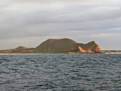 |
| Mt Cameron West. |
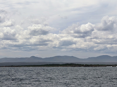 |
| North of Sandy Cape. |
The landscape unfolding off the port bow was mesmerizing as the mountains kept increasing in grandeur. For happy hour, we enjoyed some of our delicious King Island Dairy cheese, our visual and gustatory senses under simultaneous assault. It was 22:00 when we finally reached Pilot Bay, the man-made anchorage that lies between Cape Sorell and the breakwater at the entrance to Macquarie Harbour. It is easy to approach from the north and is the perfect place to wait for the right conditions before entering the harbor. The narrow entrance, known as Hells Gate, is subject to very strong tidal flows. I recommend consulting the TAG and studying the charts ahead of time. The following day we had a leisurely 08:13 start and a smooth passage through the gate, arriving at Strahan two and half hours later.
Strahan is the only surviving port on the west coast of Tasmania. In the 1800s, it primarily supported mining and logging activities. These days a small fishing fleet operates out of the port but it is mostly a hub for tourism. Our first call of duty was to refuel. The fixed wharf, designed to accommodate large commercial vessels, was not very friendly for yachts, especially with an onshore wind.
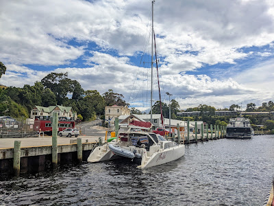 |
| Arriba docked at Strahan. |
We then anchored in nearby Risby Cove before returning to shore by dinghy. Eleven days of being at sea had made my crew desperate for one thing – a laundromat! Their excitement for laundering was only matched by their desire for cold beer, so we spent the next couple of hours alternating between the pub and the laundromat. Later, we explored Strahan on foot which took less than an hour. Learning about the town's old logging and milling days at the Morrison’s Huon Pine Sawmill was particularly interesting. Huon Pine was highly prized for its fine grain and rot resistance and quickly became of wood of choice in Tasmania in the 1800s. The trees take five hundred years to reach maturity and some are known to be three thousand years old. Today they are protected and only trees that fall naturally may be harvested.
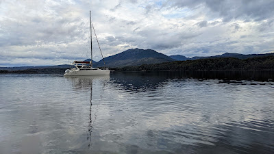
At first, we’d considered staying in Strahan for the night but once assembled on board we decided to find a more secluded spot. At 15:46, we weighed anchor and motored into a southeasterly wind that was gusting to 25 knots. Macquarie Harbour, which is sometimes described as a shallow fjord, is about 15 nautical miles long from northwest to southeast and 4 nautical miles wide. There are over a dozen anchorages and it is possible to find shelter from any direction. We chose Farm Cove, 18 nautical miles away, where we anchored at Pine Point in mill-pond calm conditions. King Island Dairy cheese was once again everyone’s happy hour choice.
At first, we’d considered staying in Strahan for the night but once assembled on board we decided to find a more secluded spot. At 15:46, we weighed anchor and motored into a southeasterly wind that was gusting to 25 knots. Macquarie Harbour, which is sometimes described as a shallow fjord, is about 15 nautical miles long from northwest to southeast and 4 nautical miles wide. There are over a dozen anchorages and it is possible to find shelter from any direction. We chose Farm Cove, 18 nautical miles away, where we anchored at Pine Point in mill-pond calm conditions. King Island Dairy cheese was once again everyone’s happy hour choice.
 |
| Arriba Farm Cove. |
The following morning we motored 3.7 nautical miles across to Sarah Island accompanied by dolphins (top photo). The island has two jetties: a large jetty, on the southern shore – which is used by tourism operators – and a smaller one, on the eastern shore, for everyone else. We went ashore at 08:45 and had the island to ourselves.
Sarah Island was the site of Tasmania's earliest penal settlement, established in January 1822. A remote island within a remote island, it was intended to be escape-proof and to inflict the harshest punishment on the worst offenders. The convicts were initially put to work chopping down Huon pines for shipment to Hobart and beyond until someone had the bright idea of exporting the wood in the form of constructed ships. For a short period, it became the largest shipbuilding operation in the Australian colonies. The settlement only lasted eleven years before it was superseded by Port Arthur. The latter is perhaps best known for modern-day brutality, namely the 1996 Port Arthur massacre – a mass shooting in which 35 people were killed.
We made our own escape at 10:30 just as the tourists from a giant power catamaran descended upon the island. For the next two hours, we motored leisurely up the majestic Gordon River. We had the river to ourselves until a couple of miles before Heritage Landing when we were passed by the tourist boat we’d dodged on Sarah Island. There is only room for one vessel at the landing and commercial operators get first dibs, so we continued upriver another half an hour before circling back. The tourist boat was gone when we returned and we enjoyed the short nature walk in solitude. Our experience of the Gordon River and its wilderness was as fleeting as it was wonderful. It is possible to sail much further upriver but at 14:09 we reluctantly turned back. Upon exiting the river, we set sail for the Kelly Basin, named after James Kelly, who entered Macquarie Harbour in 1816. The local Toogee people no doubt knew of its existence for millennia.
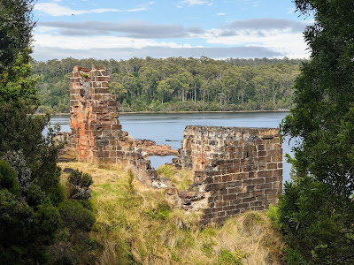 |
| Sarah Island ruins. |
We made our own escape at 10:30 just as the tourists from a giant power catamaran descended upon the island. For the next two hours, we motored leisurely up the majestic Gordon River. We had the river to ourselves until a couple of miles before Heritage Landing when we were passed by the tourist boat we’d dodged on Sarah Island. There is only room for one vessel at the landing and commercial operators get first dibs, so we continued upriver another half an hour before circling back. The tourist boat was gone when we returned and we enjoyed the short nature walk in solitude. Our experience of the Gordon River and its wilderness was as fleeting as it was wonderful. It is possible to sail much further upriver but at 14:09 we reluctantly turned back. Upon exiting the river, we set sail for the Kelly Basin, named after James Kelly, who entered Macquarie Harbour in 1816. The local Toogee people no doubt knew of its existence for millennia.
That evening we anchored in the shallow waters of West Pillinger, a ghost town with one dilapidated shack. The TAG refers to 2m of water beside the ruined wharf but we found only 1.4m and anchored elsewhere. West Pillinger was once a thriving government town but the real action was in nearby East Pillinger, about 1km over water to the east. In the late nineteenth century, it was a booming mining town of one thousand people until it was abandoned in 1924. Dense forest has now reclaimed the site and only a smattering of abandoned equipment and ruins remain. The trail between the two Pillingers was extremely overgrown and hard work. Liam and I, therefore, decided to only walk back halfway. From there we swam to Arriba, whereupon I fetched the dinghy by kayak and then retrieved the rest of our party waiting patiently on the East Pillinger jetty.
 |
| Abandoned boiler, East Pillinger. |
This would be our last taste of civilization for some time. The next day we would set sail for Port Davey.
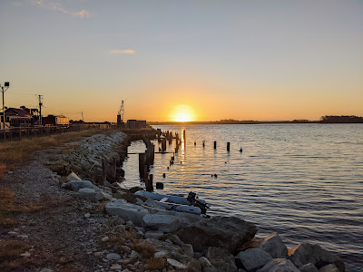 |
| Regatta Point, Strahan. |
OVER.
Comments
Post a Comment